From Point Clouds to Working Twins: 7 Shifts in Ground-Based Spatial Intelligence
The industry spent years perfecting capture. The value has moved downstream: classification, queryable twins, and the human loop that turns flags into repairs.
For years the industry recited the same workflow. Capture the area. Process the cloud. Build the model. Overlay the assets. Use it for planning and reporting. That workflow still matters. But the value has moved. Capture is now the cheapest part of the problem, and a point cloud sitting on a drive earns nothing. What earns is everything downstream: structure, query, decision, proof.
Key takeaways
- Point clouds stopped being archives and became generators: classification turns raw scans into asset registers, condition scores, and work orders.
- The twin that wins is the one you can interrogate, not the one you can rotate. Searchable beats photorealistic.
- Monsoon, dust, vegetation, and night work are the Indian continuity problem. Multi-return LiDAR and seasonal re-survey answer it the way cloud-robust processing answers it elsewhere.
- The human stays in the loop by design: AI flags at 85-95% on trained classes, engineers confirm, and the register keeps the approval trail.
1. Point clouds became generators, not archives
Traditional scanning ended with a deliverable: a registered cloud, a set of drawings, a model on a drive. Useful, and inert. The shift is that the cloud now starts workflows instead of ending them. Classified points become road furniture inventories. Deviation analyses become repair scopes. Segmented structures become BOQ line items.
This matters because manual digitising is still slow and expensive. Highway corridors need asset layers refreshed, not drawn once. Municipal wards need inventories they can query, not PDFs they can file. Heritage authorities need condition-rated elements, not photographs. If the point cloud generates these layers, the economics of every downstream product change. Value no longer sits in the capture. It sits in the conversion, which is why our 3D scanning practice treats classification as the core deliverable and the cloud as raw material.
2. Corridor intelligence goes below the centerline
Road thinking used to stop at three things: centerlines, asset dots, and a condition score. That trio describes a road the way a spine X-ray describes a patient. Necessary, and far from sufficient.
The operating geometry lives below that abstraction. Cross-slopes that pond water. Shoulders that crumble first. Drains that decide whether the pavement survives the monsoon. Turning zones, intersections, and bottlenecks where movement turns unsafe. A road twin that understands these eats the same LiDAR as everyone else and answers harder questions: not just which kilometre is poor, but which defect type, caused by what drainage failure, fixed by which treatment. Our digital twin development and highway twin writing both build from this layer down, not from the score up.
3. Monsoon-robust capture is operational continuity
Elsewhere the industry worries about cloud cover breaking satellite continuity. Here the continuity problem wears different clothes: monsoon rain, pre-monsoon dust, dense roadside vegetation, and sites that can only be occupied at night. A capture plan that needs perfect weather is a plan that misses its season.
Multi-return LiDAR sees through canopy to bare earth where photogrammetry sees leaves. Active sensors work dust and dark that ground cameras cannot. Seasonal re-survey turns the monsoon from an excuse into a schedule: pre-monsoon baselines, post-monsoon change detection, and a standing comparison that compounds in value every year. Reliability, not resolution, is the specification that decides whether a monitoring program survives contact with an Indian July.
4. Twins you can interrogate, not admire
Most twins still get judged the way real estate gets judged: how does it look, how smooth is the navigation, how clean is the dashboard. Fine qualities. Wrong test.
The working twin gets judged by what it understands. Ask it which OHTs fell below allocation this month and it should answer from meter logs, as ours does in the MVS water setup. Ask which 1890s lime-mortar walls rate condition 3 or worse and it should answer from the HBIM, as in our heritage work. Ask what changed since the last epoch and it should diff two registered clouds instead of shrugging. Photorealism through techniques like Gaussian splatting has its place in museums and portals. Operations run on queries.
5. Irregular geometry is the hard case, and heritage proves it
Building intelligence usually assumes straight walls and plumb columns, because new construction obliges. Heritage refuses. Walls lean by centimetres, arches go elliptical from long-ago repairs, floors step where interventions raised them. Idealise any of it and the model lies to everyone downstream: structural loads miscalculated, services clashing on site, regulators rejecting drawings of a building that does not exist.
Survey-first modelling that preserves as-found geometry is the answer, and heritage is simply where the discipline is strictest. The same refusal to idealise protects highway as-builts, plant retrofits, and water assets. Start from the point cloud, model what is there, and never smooth away the awkward parts. Easy to say, and it is the whole ballgame.
6. The human stays in the loop by design
Inspection AI faces a stubborn barrier everywhere: defects are rare, inconsistent, and hard to label in advance. The fashionable answer is to remove the human with lighter supervision. Our answer, stated plainly in our AI asset work, runs the other way. Detection models reach 85-95% accuracy on trained defect classes, measured across 100 km of municipal road survey data against manually inspected references. Outside that distribution, expect degradation and budget a review pass. For critical assets the loop is fixed: AI flags, engineers confirm, high-priority items never auto-close.
This is not humility for show. A model that cries wolf gets muted, and a muted model protects nothing. Calibrated flags that arrive with their evidence, get confirmed by someone with authority, and get recorded with the decision attached: that is the only inspection automation that survives its first year. The register keeps the approval trail, not just the recommendation.
7. Twins that live with their owners
A twin of a factory, a road network, or a water scheme holds operational truth, which raises two questions most vendors answer badly: who owns the data, and who can act on it. Our answer to the first is structural. Open tooling, QGIS, PostGIS, GeoServer, IFC delivery: the municipality or the asset owner holds the registry, not a licence server. Sovereign data outlasts vendor roadmaps, and auditability beats elegance in public infrastructure.
The second question belongs to governance, which we treat at length in our asset-register piece: field notes inform, meter logs trigger inspection, calibrated readings authorize spending. Each tier recorded with its provenance. A twin that cannot say who approved what, on which evidence, is a viewer with opinions.
The real message: the stack compounds from the ground up
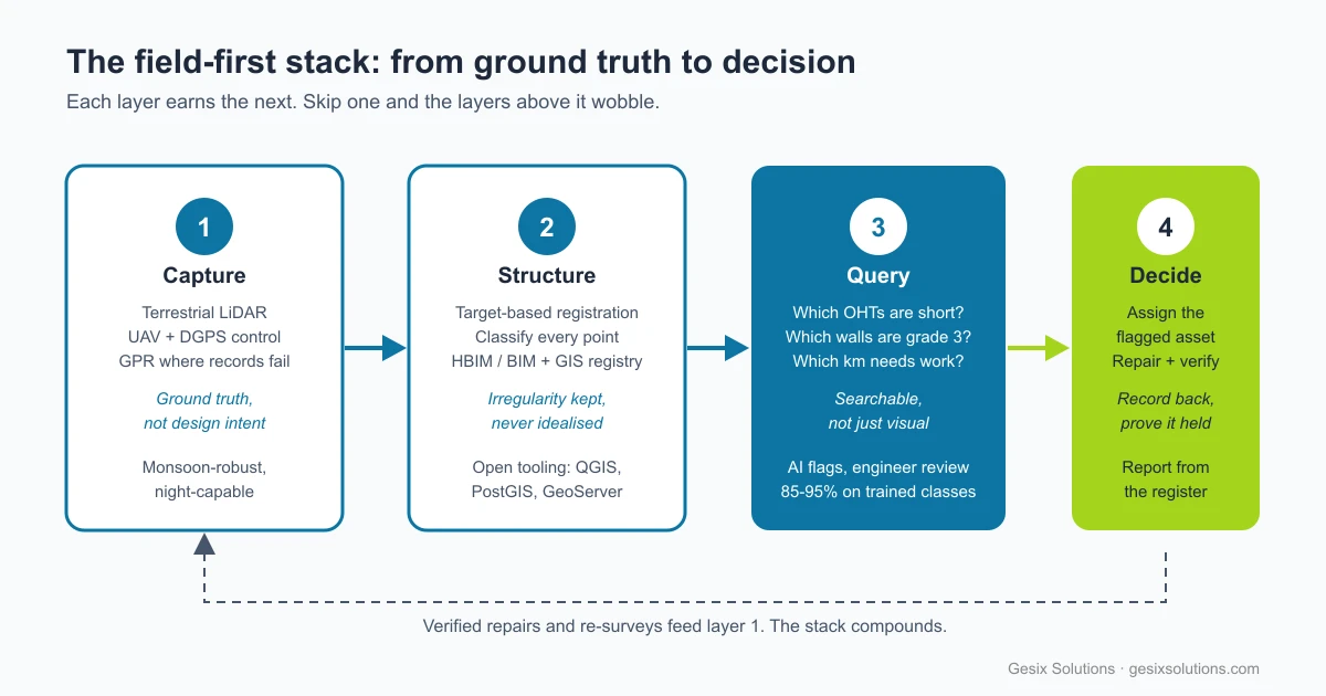
Pull the seven shifts together and one pattern holds. Capture earns the right to structure. Structure earns the right to query. Query earns the right to decide. Decision, recorded and verified, earns the next capture. Skip registration discipline and the queries lie. Skip the query layer and the twin is decoration. Skip assigned responsibility and the flags rot in a dashboard.
| Layer | Old habit | Field-first habit |
|---|---|---|
| Capture | Best resolution money buys | Ground truth to control, monsoon-robust |
| Structure | Drawings and idealised models | Classified clouds, irregularity preserved |
| Query | Rotate, zoom, admire | Ask, compare epochs, rank by risk |
| Decide | Phone calls and memory | Assigned flags, recorded evidence |
The next advantage will not go to whoever holds the most imagery or renders the prettiest twin. It will go to whoever converts physical reality into structured, queryable, owned intelligence the fastest, and proves each decision against the next survey.
Do not just scan the asset. Give it an address, a history, and someone accountable.
At Gesix, that is the whole practice: terrestrial truth, open registries, AI that flags and engineers who confirm, twins that answer questions instead of posing for screenshots. Because the future of spatial intelligence is not better looking. It is better answered.
Frequently Asked Questions
What is a working twin as opposed to a visual twin?
A visual twin shows geometry you can rotate and inspect. A working twin answers operational questions: which assets are degraded, which zones are short, what changed since last epoch, and which repair the evidence supports.
Why does ground-based capture still matter when satellites and drones cover everything?
Millimetre accuracy, underside geometry, interiors, and controlled survey networks still need terrestrial LiDAR and total-station control. Aerial coverage gives context. Ground truth gives engineering liability.
What breaks most often when teams build their first twin?
Skipped layers: targetless registration, unclassified clouds, models nobody queries, and flags nobody is assigned to close. Each skipped layer quietly invalidates the ones above it.
Should AI replace manual inspection in infrastructure twins?
No. Detection models reach 85-95% accuracy on trained defect classes (measured across 100 km of municipal road survey data), but only inside their training distribution. The durable pattern is AI flags plus engineer confirmation, especially for critical assets.
How should an organisation start?
One asset class, one loop, one register: capture to survey control, classify, query, assign, verify. Open tooling (QGIS, PostGIS, GeoServer) keeps the data inside the organisation while the loop proves itself.