3D Laser Scanning & Scan-to-BIM in Bangalore.
Headquartered in Bangalore, we provide rapid-deployment Reality Capture, Scan-to-BIM, and DGCA-certified UAV surveying across Karnataka. Delivering engineering-grade geometry for industrial retrofits, commercial real estate, and municipal infrastructure.
Our Regional Expertise
From millimeter-accurate LiDAR scanning in Peenya to highway UAV surveys across Karnataka — one integrated workflow.
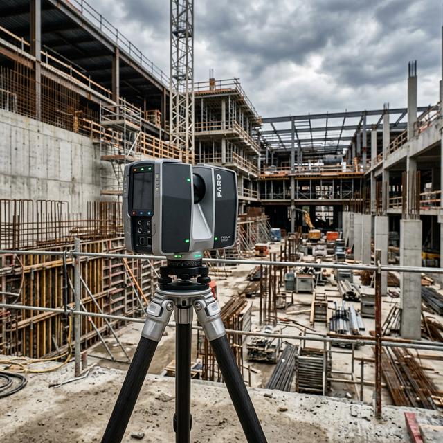
LiDAR Scanning in Bangalore
Precision FARO and Leica scanners capture millimeter-accurate point clouds of commercial buildings, industrial plants in Peenya, and heritage monuments across Karnataka — georeferenced for BIM and digital twin workflows.
Scan to BIM Services
Registered point clouds from active Bangalore sites converted into IFC-compliant as-built models at LOD 300–400. Direct deliverables for retrofit design and MEP clash detection.
UAV Photogrammetry Karnataka
DGCA-certified drone surveys for large-area terrain mapping, highway corridors, and solar farm site assessments across Karnataka.
Infrastructure Digital Twins
Building local digital twins for smart city infrastructure, flyovers, and water supply networks linking physical assets to operational data.
Local Service Questions
Your Local Scanning Partner.
Based in Basaveshwarnagar, we can mobilise our Leica and FARO scanning teams to any site in Bangalore within 24 hours. Contact our local office directly.
Call: +91 84315 27304
Contact HQ