Demolishing a Heritage Structure Isn't Progress. It's a Failure of Engineering Imagination.
Adaptive reuse of historic buildings is technically demanding, but resorting to demolition is a failure of engineering imagination. Discover how reality capture and digital twins make the impossible solvable.
Every time the wrecking ball swings at a historic building, we are told it is the price of progress. We are told the structure was too inefficient, too unsafe, or simply too complex to adapt for modern needs. But let’s be clear: in the modern architectural and engineering landscape, resorting to demolition is rarely a necessity. More often than not, it is a failure of engineering imagination.
Adaptive reuse—converting a heritage structure to a new function while preserving its historic fabric—is undeniably one of the most technically demanding disciplines in the built environment. There is often a massive gap between a building's original structural logic and the stringent demands of contemporary building codes, sustainability targets, and user expectations. Navigating that gap requires a profound, precise understanding of the structure as it exists today, not as it was designed a century ago on fragmentary, long-lost paper records.
The excuse that a building is "too complex" to save vanishes when we apply modern reality capture and spatial engineering.
The Reality Capture Revolution
In heritage as-built documentation, non-intrusive methodologies are absolutely critical. You cannot effectively plan a deep renovation or a seismic retrofit based on guesswork. Deploying equipment like the FARO S350 scanner on-site allows us to capture the irregular geometries, complex masonry, and natural settling of a historic asset with millimeter-level precision—all without touching delicate historical surfaces. Explore our heritage documentation and scanning services.
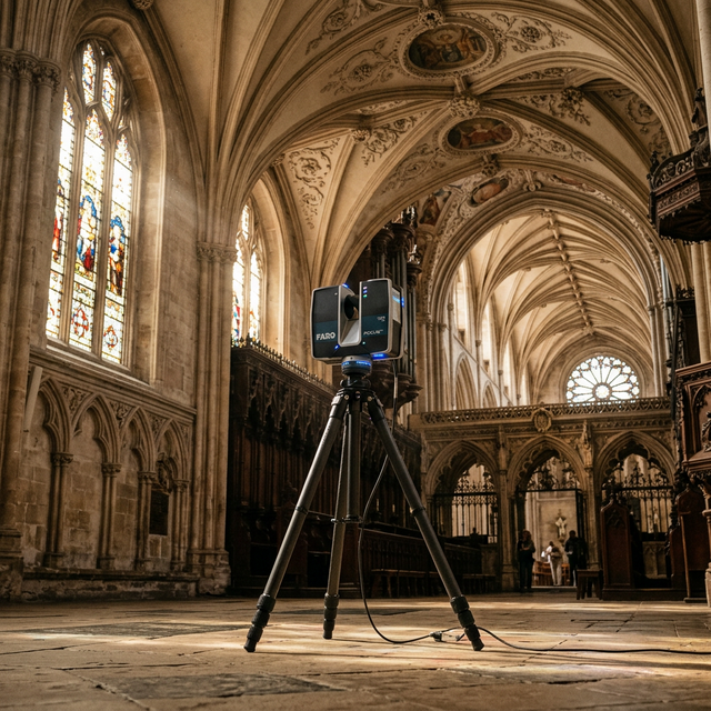
When we combine terrestrial laser scanning with drone surveying and advanced photogrammetry, we generate a comprehensive, highly accurate point cloud. This maps the exact physical reality of the site. We are no longer limited to idealized, parametric shapes; we can model the building exactly as time and history have shaped it.
Beyond the Point Cloud: Digital Twins and Visual Fidelity
Capturing the data is only the first step; the true engineering imagination lies in how we interpret and utilize it. To push the boundaries of how we document and interact with these spaces, we are heavily leveraging Gaussian Splatting. This technique allows for unprecedented, high-fidelity visual representations of complex heritage structures, providing stakeholders with a photorealistic, navigable understanding of the site before a single hammer is swung.
This rich visual and geometric data feeds directly into Heritage Building Information Modeling (HBIM). By unlocking the Scan-to-BIM workflow, we transition from raw data points to a functioning, queryable Digital Twin.
Enabling Smart, Invisible Engineering
With an accurate HBIM model, the "impossible" engineering challenges of heritage conservation become entirely solvable:
- Seismic Retrofitting: Instead of brute-force structural additions, engineers can use performance-based design to model how specific interventions—like discreet tension rods or hidden shear walls—will perform, maximizing life safety while minimizing the impact on the historical fabric.
- Modern Systems Integration: Need to route modern HVAC or smart-building sensors without destroying vaulted ceilings or decorative plaster? A 3D model reveals exactly where the existing cavities and safe-zones are.
- Net-Zero Upgrades: Improving energy performance no longer means ripping out historic facades. We can model the integration of conservation-compatible solutions, such as implementing ultra-thin vacuum-insulated glass into original period sash windows, achieving modern thermal efficiency while satisfying strict heritage planning regulations.
Contextualizing Heritage in the Modern City
These buildings do not exist in a vacuum. By integrating this high-resolution building data with broader geospatial workflows—drawing on over a dozen years of deep, practical experience utilizing platforms like QGIS—we can view heritage sites not as isolated relics, but as active nodes within a smart city. This level of spatial intelligence is the exact same foundational logic we apply when building comprehensive municipal asset management systems for modern infrastructure.
At Gesix Solutions, we know that the built environment represents a vast reservoir of embodied carbon and irreplaceable cultural memory. We have the technology to diagnose, digitally reconstruct, and adapt these structures for the 21st century. Demolition is the easy way out. True engineering excellence lies in honoring our past while intelligently engineering our future.